
Watershed Approach
Watershed Basics
What is a Watershed?
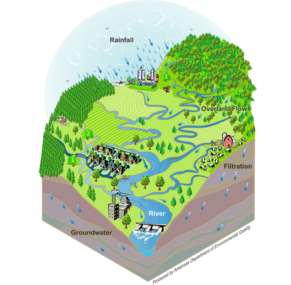
A watershed is an area of land that drains to a common waterway, such as a river, stream, lake, estuary, aquifer, or even an ocean. Watersheds can be as small as a field, a yard, or a parking lot, or as large as a country. Unlike property lines or city borders, watershed boundaries are shaped by the land’s natural features and often cross towns, counties, and other human boundaries. Smaller waterbodies flow into larger ones, eventually forming large drainage networks and river systems.
What are HUCs?
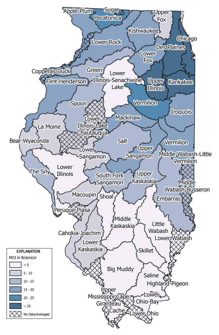
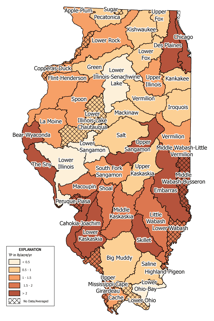
The U.S. Geological Survey, in cooperation with the U.S. Department of Agriculture Natural Resources Conservation Service, created hydrologic unit codes, or HUCs, to identify watershed boundaries and sizes. Illinois has 1,889 HUC-12s, 409 HUC-10s, and 51 HUC-8s. HUC classification helps scientists and communities better track, protect, plan, and manage water resources. For instance, analyzing nutrient loads and yields at the HUC-8 watershed scale allows the Illinois Nutrient Loss Reduction Strategy to estimate and compare nitrate and phosphorus losses across different parts of Illinois.
WA.01: Nitrate Plus Nitrite 2018-22 Annual Average Losses (lb/acre/yr) From Illinois HUC-8 Watersheds
WA.02: Total Phosphorus 2018-22 Annual Average Losses (lb/acre/yr) From Illinois HUC-8 Watersheds
NLRS Priority Watersheds in Illinois
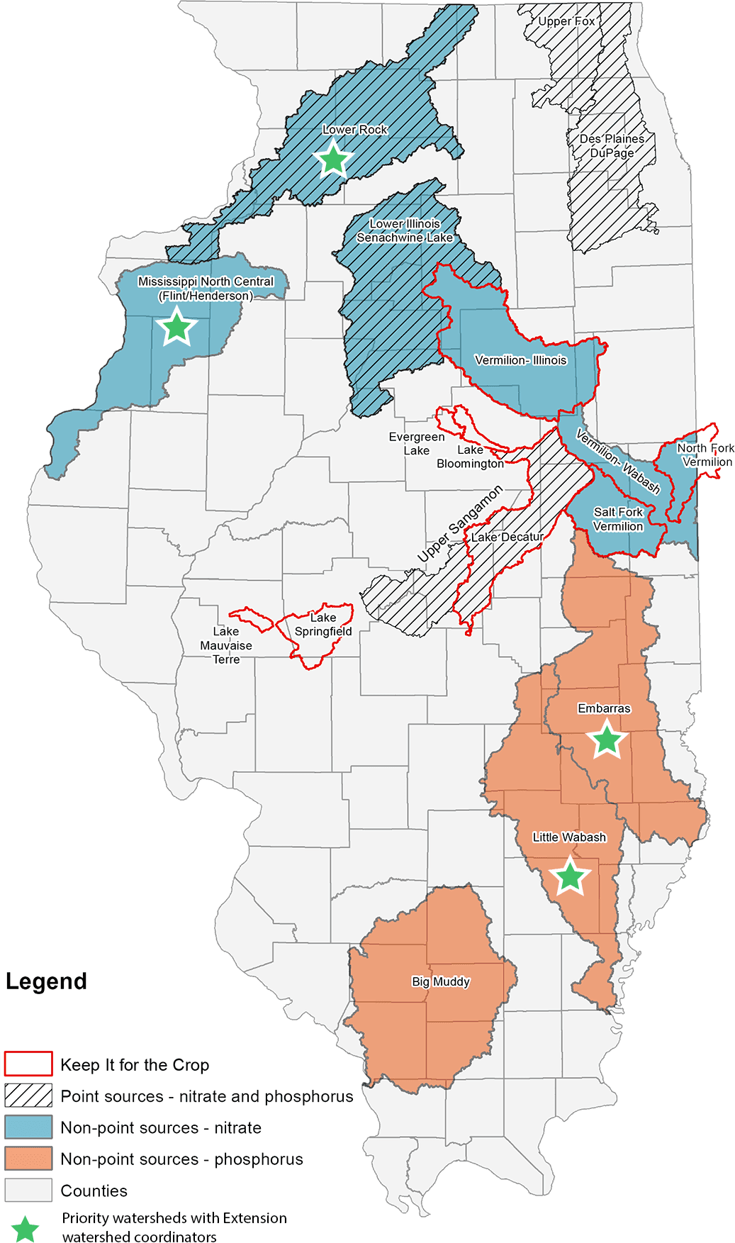
The Illinois Nutrient Loss Reduction Strategy focuses efforts on priority watersheds identified in the 2015 NLRS science assessment. These watersheds were identified based on nitrogen and phosphorus loss levels, local water quality concerns, and existing watershed plans. Focused efforts within these watersheds offers the greatest opportunity to reduce nutrient losses and improve water quality across Illinois. These efforts may include a range of activities tracked through NLRS logic models—including financial & staff resources, outreach, land and facilities implementation, and water quality research—as well as additional research initiated through the strategy and partner-led initiatives in education, outreach, professional networks, and cost-share funding.
WA.03: Illinois NLRS Priority Watersheds
Watershed Planning
Overview of Watershed Planning Approach
Watershed planning looks at the big picture of how land use and human activities influence surface water quality. Working together, communities, agencies, and organizations create shared goals and strategies that seek to improve water quality, protect ecosystems, and build resilience to climate change. Watershed plans may include both voluntary actions and regulatory programs to meet water resource goals.
Watershed plans are managed adaptively and can lead to significant improvements in both local and downstream water quality.
The Illinois EPA and many NLRS partners work with watershed groups across the state to reduce nutrient pollution from farms, sewage systems, and urban stormwater, helping to protect our waterways for the future.

Watershed-Based Plans
Watershed-based plans are specific watershed plans designed to meet the U.S. Environmental Protection Agency’s nine elements of a watershed plan. A watershed-based plan summarizes the overall condition of the watershed and provides a framework to restore impaired waters and to protect water quality in other waters adversely affected or threatened by nonpoint source pollution. Illinois EPA’s Section 319(h) Grant program provides annual cost-share funds for the development of watershed-based plans.
Plans developed and approved within the last 10 years are considered active. As of 2016-2025, there are 52 approved watershed-based plans and 4 in development.
Pollution Reduction Potential
Fully implementing watershed-based plans could lead to nonpoint source pollution control in urban and rural watersheds, resulting in significant improvements in water quality across Illinois.
WA.04: Estimated Pollutant Load Reductions If All Active Watershed-Based Plans (WBPs 10 years old or less) Are Fully Implemented in Illinois
| Metric | WBPs 2016-25 |
|---|---|
| Number of Plans | 52 |
| Nitrogen (lb/yr) | 6,731,173 |
| Phosphorus (lb/yr) | 1,254,539 |
| Sediment (tons/yr) | 551,223 |
WA.05: Locations of Watershed-Based Planning Efforts
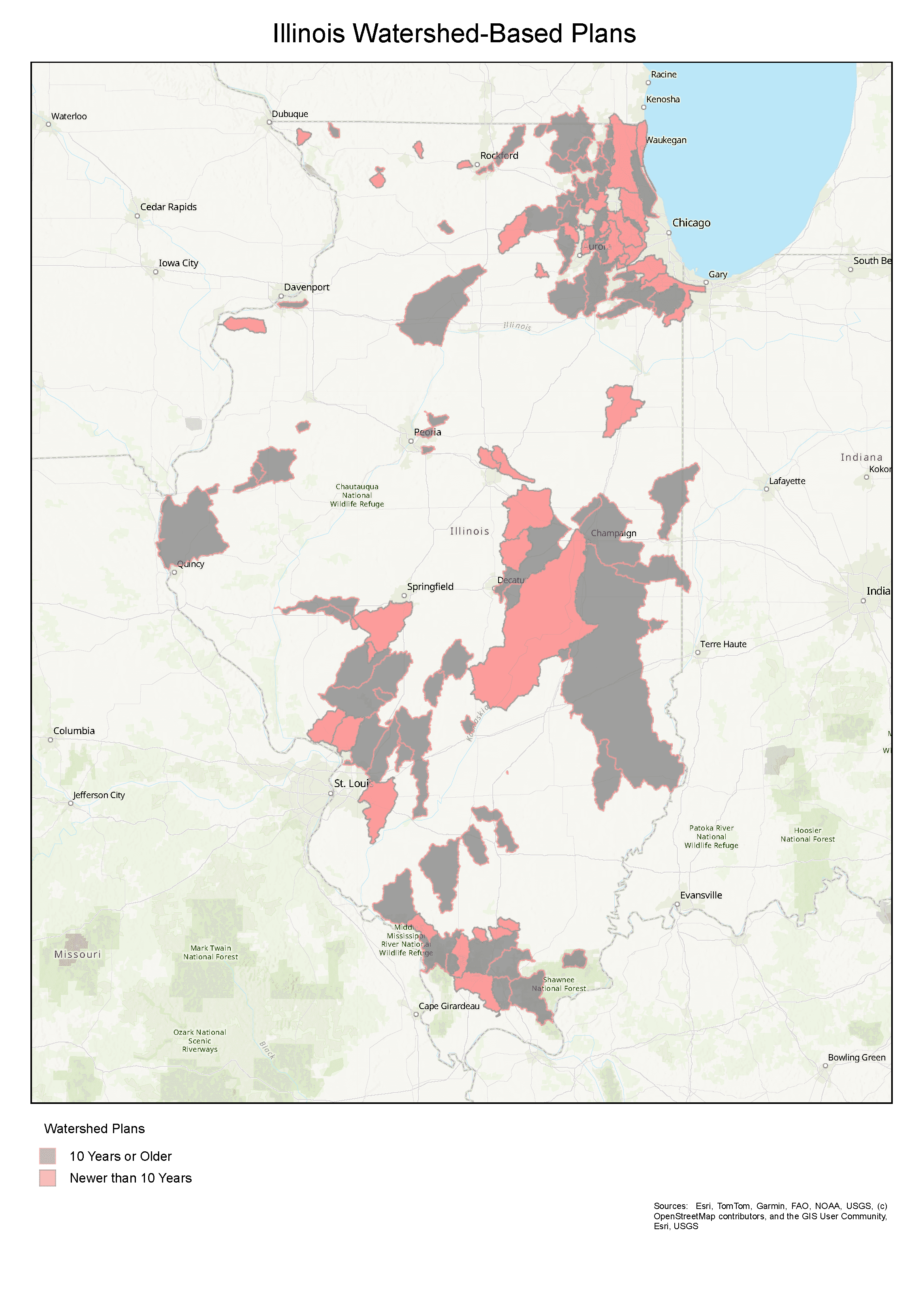
More details on watershed-based plans can be found on the Illinois Resource Management Mapping Service and the Illinois EPA website.
Total Maximum Daily Loads
The Illinois EPA develops total maximum daily loads, TMDLs, limits for impaired waterbodies. A TMDL is the calculation of the maximum amount of a pollutant allowed to enter a waterbody so that it will meet water quality standards for a pollutant.
A TMDL determines the maximum amount of a pollutant a water body can assimilate and still meet water quality standards. Pollutant loads are allocated to sources of each pollutant. Subsequent pollutant load reductions are established to meet the TMDL target load.
Point source waste load allocations vary, depending on the magnitude of loadings from point sources in a watershed and the degree to which the water quality standard is exceeded. Point source reduction goals vary for TMDLs with nutrient-related point source contributions. These goals are incorporated into NPDES permits at renewal or modification stages.
A TMDL takes a watershed approach in determining the pollutant load that can be allowed in a lake or stream. By taking a watershed approach, a TMDL considers all potential point and non-point sources of pollutants. It also takes into account a margin of safety, which reflects scientific uncertainty and future growth. The effects of seasonal variation are also included.
As of 2025, the U.S. EPA has approved 152 total phosphorus TMDLs and 11 nitrate-nitrogen TMDLs.
View the TMDL reports and learn more about the Illinois EPA TMDL Program.
Watershed Approach Implementation by Sector
Point Sources
The Illinois EPA requires certain point source facilities to participate in local watershed groups as a condition of their National Pollutant Discharge Elimination System, NPDES, permits to address nutrient-related or dissolved oxygen impairments in downstream waterbodies. These watershed groups include:
- Des Plaines River Watershed Workgroup
- DuPage River Salt Creek Workgroup
- Fox River Study Group
- Lower Des Plaines Watershed Group
- Lower DuPage River Watershed Coalition
- North Branch Chicago River Watershed Workgroup
Additional details about these groups can be found in Partner Updates 2025 and Partner Updates 2023-24 under Supporting Documents on the Illinois EPA NRLS website. Partner Updates for all years 2017-25 can be found in the NRLS Partner Narratives Library.
Urban Stormwater
The following organizations develop and implement watershed plans as part of their work. These include:
- Chicago Metropolitan Agency for Planning
- DuPage County Stormwater Management
- Greater Egypt Regional Planning and Development Commission
Additional details about these groups can be found in Partner Updates 2025 and Partner Updates 2023-24 under Supporting Documents on the Illinois EPA NRLS website. Partner Updates for all years 2017-25 can be found in the NRLS Partner Narratives Library.
Agriculture
There are many active watershed groups throughout Illinois working to improve water quality in local waterways and downstream. NLRS agricultural partners are involved in these efforts, which include strategies for non-point nutrient reduction. Examples include:
- Upper Macoupin Creek Watershed Partnership
- Vermilion Headwaters Watershed Partnership
- Lake Springfield Watershed partners (see Water Supply & Industry Partnerships, Nutrient Stewardship Grant Program, and Partnerships with Drinking Water Suppliers and Wastewater Treatment Plants)
- Lake Decatur Watershed partners (see Water Supply & Industry Partnerships, Nutrient Stewardship Grant Program, and Partnerships with Drinking Water Suppliers and Wastewater Treatment Plants)
- Mississippi North Central (Flint/Henderson) Watershed partners (see IFB NLRS Priority Watershed Work and Nutrient Stewardship Grant Program)
- Embarras River Watershed partners (see IFB NLRS Priority Watershed Work and Nutrient Stewardship Grant Program)
- Mackinaw River Watershed (see Mackinaw River Program)
- Lake Bloomington Watershed partners (see Nutrient Stewardship Grant Program)
- Kaskaskia Watershed Association
Additional details about these groups can be found in Partner Updates 2025 and Partner Updates 2023-24 under Supporting Documents on the Illinois EPA NRLS website. Partner Updates for all years 2017-25 can be found in the NRLS Partner Narratives Library.